


 Lists on HOSE: Unlocking the Value of Masan’s Ecosystem in the Capital Market?")


: Mixed Signals Emerge")

: Short-Term Outlook Continues to Deteriorate")
Vietnam is the world’s second-largest producer of coffee, with 93% of its total output coming from the Central Highlands region. However, the rapid expansion of coffee production in this area has caused significant environmental damage, including increased risks of deforestation, water pollution, soil degradation, climate change, and abnormal weather patterns, which, in turn, affect coffee production.
The topic of sustainable coffee development has gained wider attention since the introduction of the European Union’s new Anti-Deforestation Regulation (EUDR). Coming into force in December 2024, EUDR requires importers of certain agricultural products, including coffee, into European territory to provide evidence that their production is not associated with deforestation since January 1, 2021. This requires not only accurate location information of farms or plantations but also highly reliable information on forest locations.
In the race to meet the reporting requirements of this newly emerged geospatial data, Vietnamese coffee companies realized they lacked high-accuracy data on the locations of forests and coffee farms. Current global Earth observation datasets do not provide the necessary accuracy for local-level analysis and can even lead to misrepresentation in remote areas where communities are more vulnerable. Indeed, the EU’s 2020 Global Forest Cover map shows that over 50% of locations that are, in fact, coffee farms are represented as forests on the map (Figure 1)
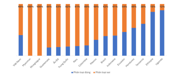
Source: Ørtenblad et al. “Exploring the EU’s New Deforestation Regulation in the Coffee Sector: Challenges and Opportunities with Remote Sensing Solutions.” Manuscript submitted to the scientific journal “Land Use Policy.”
To meet this geospatial data demand, the International Union for Conservation of Nature and CIAT, along with partners (the Nordic Development Fund, the University of Copenhagen, Rainforest Alliance, and the ECOM Group), developed the Terra-i+ tool (https://www.terra-iplus.org/), leveraging nearly two decades of experience in monitoring deforestation from satellite data.
Through a rigorous scientific validation process, the Terra-i+ land cover map achieves the highest accuracy for coffee and natural forest classification, with accuracy and sensitivity ranging from 80-90% (specifically, accuracy assesses the rate of “false positives,” which is the probability that any point on the map belongs to the corresponding class on the ground; while sensitivity assesses the rate of “false negatives,” which is the probability that any point on the ground is correctly classified on the map)
Such accuracy is not easily achievable with coffee canopy maps due to the difficulty in distinguishing tree canopy features from satellite images. Therefore, the Terra-i+ land cover map is considered the highest resolution and most accurate among the published land cover maps.
Another notable feature of Terra-i+ is its ability to identify potential areas for agroforestry development. By employing a novel method to map the measurement of tree canopy density, coffee, and bare soil (unvegetated), the Terra-i+ team created a map of coffee cultivation areas divided into thresholds from high-canopy coffee to no-canopy coffee. The canopy threshold classification has been calibrated to match the conditions and context of coffee cultivation in Vietnam.
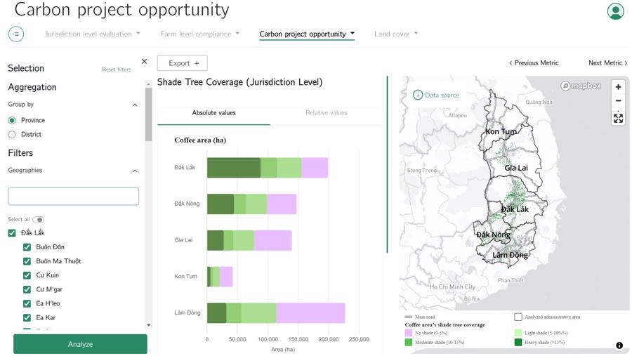
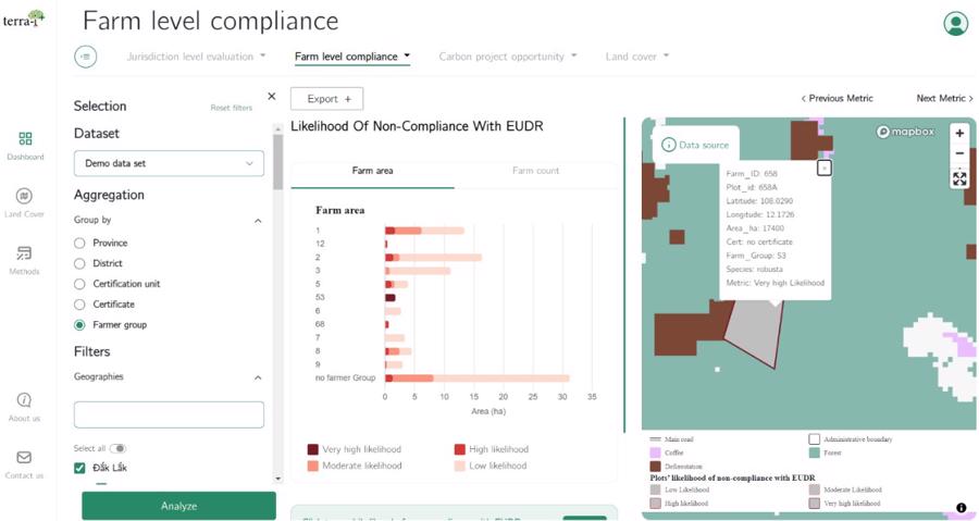
In addition to building highly accurate local-level datasets, Terra-i+ enhances users’ access to geospatial data through its user-friendly interface design and tailored features, such as EUDR compliance, canopy density on coffee farms, deforestation monitoring, and water pollution and climate risks.
Terra-i+ is currently being used by ECOM, one of the world’s leading coffee companies operating in Vietnam, to manage deforestation risks and provide information on agroforestry intervention measures.
“Previously, to estimate the risk of coffee-related deforestation and canopy density on coffee farms, we had to rely on surveys combined with local expert knowledge. Now, we can use more accurate and high-resolution data from the Terra-i+ tool for this purpose,” said Thuan Sarzynski, Director of Sustainable Development in Vietnam at the ECOM Group.
For more information, please contact the Terra-i+ team at email: [email protected] or visit the website: https://www.terra-iplus.org/about-us.
Bình Thuận’s Dragon Fruit: A New Path for Sustainable Agriculture and Reduced Emissions

The initial successes in growing dragon fruit and reducing greenhouse gas emissions, as well as carbon footprint tracking in Binh Thuan, are evidence that Vietnam has, is, and will be able to apply innovative approaches to develop sustainable agriculture, adapting to climate change…
5 “King” figures that brought in billions of dollars, elevating Vietnam’s reputation in the global market

The following are 5 products considered as the “Export Kings” of Vietnam in 2023 and have significant breakthrough potential in 2024.
First step in Mr. Dang Le Nguyen Vu’s plan to make 1 trillion USD: Opening 1,000 Trung Nguyen Legend stores in China and expanding into a global chain.

By the end of 2023, Vietnam’s economy is expected to reach a new nominal scale of 430 billion USD. However, Mr. Dang Le Nguyen Vu – the famous Chairman of Trung Nguyen Legend – boldly declares, “I will generate at least 1,000 billion dollars for Vietnam,” and confidently adds, “there must be something extraordinary behind such a statement!”
Minister Le Minh Hoan: Deepening the dissemination of agricultural economic thinking

Minister of Agriculture and Rural Development, Le Minh Hoan, believes that it is necessary to further promote the agricultural economic mindset, in order to maximize the value generated on agricultural units per unit of land.
Vietnamese Product Ranks Top 5 Globally, Generates Nearly $1.5 Billion in One Month

Customers from Asia to the United States are absolutely thrilled with this amazing product from Vietnam. It has quickly risen to the top 5 in global rankings, generating an impressive export revenue of nearly $1.5 billion within just one month.


