
Multiple “Golden Land” Auction Blocks
The People’s Committee of Tan Phu District, Ho Chi Minh City, has just issued a plan to implement the TOD area along the Metro Line 2 (Ben Thanh – Tham Luong) according to the National Assembly’s Resolution 98 in Tan Phu District.
Accordingly, the organization reviewed the TOD area to organize the exploitation of land funds with conditions for rearrangement and development in the area around the Metro Line 2 stations.
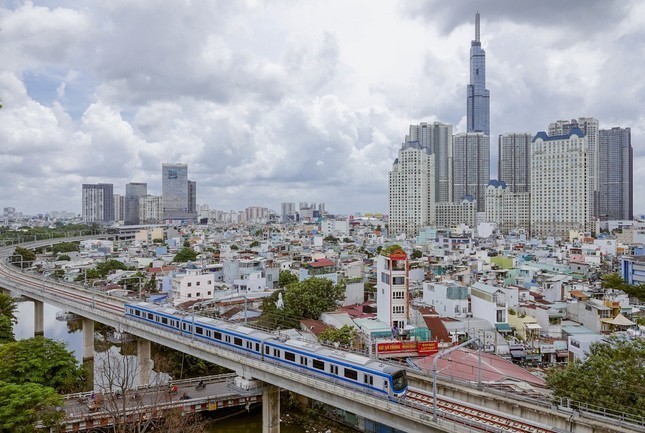
Ho Chi Minh City will auction many land plots to develop the TOD model along Metro Lines 1-2 and Ring Road 3. Photo: Duy Anh.
In the first quarter of 2025, Tan Phu District will approve the policy of adjusting the local planning. Subsequently, it will prepare and approve the list for the local planning adjustment report. Then, the approved list for the local planning adjustment will be submitted.
Tan Phu District proposes to allocate Ho Chi Minh City’s budget for local planning adjustment; develop and approve the plan for selecting contractors, and approve the contractor selection plan; conduct bidding to choose planning consultants, etc., in the first quarter of 2025.
By the second quarter of 2025, Tan Phu District will prepare the local planning adjustment plan, organize the appraisal of the local planning adjustment, and then approve the planning adjustment.
In the third quarter of 2025, Tan Phu District will establish and approve the list of land recovery projects and the land use plan. In the fourth quarter of 2025, it will carry out compensation, support for resettlement, and auction for contractor selection. Subsequently, the investment project will be approved, and construction will be deployed in the fourth quarter of 2025.
The auctioned land plot is Plot I/82A Tay Thanh, with an area of 26 hectares, adjacent to Tay Thanh and Truong Chinh streets. According to the approved TOD planning by Ho Chi Minh City, this area will function as mixed-use land, investing in a compact urban area, while also exploiting underground space to optimize land use efficiency around Metro Line 2 stations.
Similarly, the People’s Committee of Thu Duc City announced that it would auction three land plots to develop the TOD model along the Metro Line of Ben Thanh – Suoi Tien and Ring Road 3.
The first is a 160-hectare land plot located around the metro station in Phuoc Long Ward, Truong Tho and Phuoc Long A. This area is connected to the Metro Line of Ben Thanh – Suoi Tien and is planned to have a mixed-use function and public works.
The second is the Coconut Farm land in Long Truong Ward, with an area of 152 hectares connected to Ring Road 3. This land plot is planned for mixed-use and public works.
The last plot is among the nine locations that Ho Chi Minh City has planned for TOD development in the 2025-2026 period. Metro Line 1 will develop TOD around Phuoc Long Station (in Truong Tho, Thu Duc City), with an area of over 160 hectares. For Metro Lines 2 and 3, TOD will be implemented in Tay Thanh, Tan Binh Exhibition and Sports Center, and the C300 area near the Le Thi Rieng Station.
64,000 hectares of land with potential for TOD development
According to the plan of the People’s Committee of Ho Chi Minh City, in the next ten years, 355 kilometers of urban railways will be completed, and TOD will be developed in 11 locations along the metro stations. For Metro Line 2 (Ben Thanh – Tham Luong), three land plots will be recovered, including the Exhibition and Sports Center of Tan Binh District, with an area of 5.1 hectares; Plot I/82A Tay Thanh in Tan Phu District, with an area of 26 hectares; and the C300 plot, located between District 10 and Tan Binh, with an area of nearly 41 hectares, to develop the TOD model.
In the period of 2025-2026, Ho Chi Minh City plans to develop TOD at nine locations along three major transport projects: Metro Line 1 (Ben Thanh – Suoi Tien), Metro Line 2 (Ben Thanh – Tham Luong), and Ring Road 3. The largest TOD location is in Xuan Thoi Thuong, Hoc Mon District, with an area of over 389 hectares, while the smallest is the Exhibition and Sports Center of Tan Binh District, with an area of about 5.1 hectares.
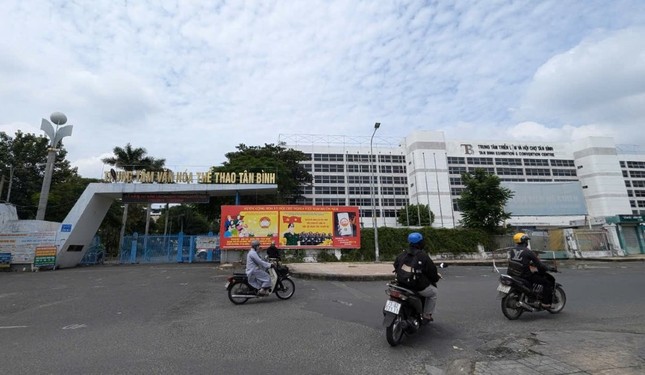
The Tan Binh Exhibition and Sports Center, covering about 5.1 hectares, will become a TOD. Photo: LDO.
According to data from the Department of Construction, Ho Chi Minh City is estimated to have about 64,000 hectares of land that can be developed for urban areas oriented towards public transport. Of this, about 32,000 hectares are agricultural land or vacant land, 9,000 hectares are industrial or production land or land with changed functions, and 23,000 hectares are urban land that needs to be converted or renovated for TOD development.
For Ring Road 3, there are five TOD development locations, including the Coconut Farm and Long Binh land plots in Thu Duc City; the Tan Hiep area, Plot 6 of Xuan Thoi Thuong, and Xuan Thoi Son in Hoc Mon District.
The total area of these TODs is over 1,000 hectares, and each urban area is almost a miniature satellite city of the central areas. Ho Chi Minh City has proposed three models for implementing TODs along metro and ring road lines. The first is the TOD model in the core area of the station (within a radius of 400-500 meters).
This model will develop a high-density urban area with optimized mixed-use land, multi-functional commercial services, and residential areas; walking is the primary mode of transportation within the TOD area, and external transportation relies mainly on the urban railway system.
The second is the TOD model in the station’s transition area (outside the 400-500-meter radius and within the 800-1,000-meter radius), which will develop a high-density urban area with mixed-use land for housing and social services; internal transportation relies mainly on walking and cycling, and the station is connected by bus or light personal vehicles (bicycles, electric vehicles, etc.); external transportation still relies primarily on the urban railway system.
Finally, there is the concentrated urban model in the peripheral areas of the Ring Road 3 intersections. This model will form concentrated residential areas, urban functional areas, industrial parks, logistics centers, etc. It will feature mid- and high-rise development around the core center, with mixed-use land for residential and social services; internal transportation relies mainly on bicycles and electric vehicles, and external transportation is connected to branch roads and public transport.
The Power of Persuasive Writing: Crafting a Compelling Title
“An Gia’s (AGG) The Gió Riverside: 2,500 Sales and Counting – A Spectacular Launch”
 The Gió Riverside: 2,500 Sales and Counting – A Spectacular Launch”")
On March 11, An Gia Real Estate Group (Ticker: AGG) hosted an event titled “The Wind’s Day,” marking the launch of their new project, The Gió Riverside, and a significant strategic step forward for the developer in Ho Chi Minh City’s thriving East market.
The Rise of Vietnam’s Millionaires: Unlocking the Potential of the Country’s Luxury Real Estate Market

According to a report by New World Wealth and Henley & Partners, Vietnam is one of the countries with the fastest-growing millionaire populations (defined as individuals with a net worth of over $1 million) in the world, experiencing a remarkable 98% growth between 2013 and 2023.
The Heart of Ho Chi Minh City’s Future: International Financial Center on 9.2 Ha in Thu Thiem

This vacant lot boasts a meticulously planned infrastructure, encompassing seamless transportation, electrical, and telecommunication networks, as well as illumination amenities. It is strategically located within the Functional Area No.1 of the thriving Thu Thiem New Urban Area.
“Ho Chi Minh City’s Vision: AI, Big Data, and Innovation Hub in Thu Duc City”

Alongside investing in transportation infrastructure, Ho Chi Minh City plans to boost the development of a multi-purpose high-tech hub, with a focus on AI, Big Data, and innovation, slated to be located in Thu Duc City.
Unlocking the Artery: The $45 Million Project to Revitalize Thu Duc’s Lifeline

The Luong Dinh Cua Road Upgrade Project in Thu Duc City has been delayed for almost a decade due to challenges with land clearance. This vital infrastructure development has faced significant hurdles, causing extensive hold-ups and impacting the lives of residents and businesses in the area. With such a lengthy delay, the project has encountered numerous challenges and has had to navigate a complex path to get back on track.


