
Ho Chi Minh City’s vision for 2060 is to become a leading economic, financial, and service center in Asia, serving as a growth pole and driving force for the development of the Southern region and the entire country.
According to the approved plan, Ho Chi Minh City’s vision for 2060 is to become a global city, known for its civility and modernity, with a development level on par with major cities worldwide. The city aims to be a leading economic, financial, and service hub in Asia, serving as a growth pole and driving force for the Southern region and Vietnam as a whole. It strives for a high standard of living and quality of life, with a unique cultural and economic development that attracts international financial institutions and economic groups.
The city’s urban development goals focus on promoting creativity and high interactivity, coupled with the growth of knowledge-based and high-tech economies, to enhance socio-economic development effectiveness. Forming dynamic areas to leverage the city’s role as a regional and national growth center is crucial.
Infrastructure connectivity is a key aspect, with a focus on linking Ho Chi Minh City to neighboring localities, the rest of Vietnam, and international destinations, following strategic and priority initiatives. Intra-city connectivity is also vital for efficient urban operations, with a focus on developing public transportation-oriented urban areas.
Redeveloping existing urban areas, expanding urban spaces, optimizing land use, and maximizing the technical infrastructure system are priorities. The goal is to create diverse urban spaces that maximize job opportunities and strive for international standards in urban services.
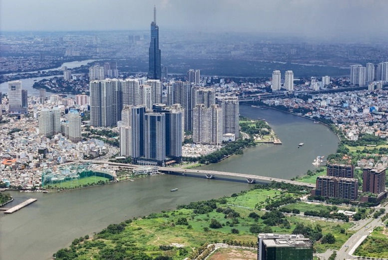
Preserving and promoting the unique architectural, landscape, and ecological values of the city, especially the characteristics of a riverine and coastal urban area, while adapting to climate change, are essential aspects of this vision.
Developing a Multi-Center Urban Model with 6 Sub-Regions
Regarding the urban nature, the decision emphasizes that Ho Chi Minh City is a special urban area under the direct management of the Central Government. It serves as a critical economic, cultural, educational, scientific, and technological center for the nation, taking a pioneering role in innovation and creativity. The city holds a significant position in the national urban development strategy and is one of the leading tourism, financial, commercial, and logistics centers in Southeast Asia and the Asia-Pacific region. It is also an ASEAN healthcare hub.
Ho Chi Minh City is a vital transportation and digital infrastructure hub in the Southeast region, nationally and internationally. It serves as a regional link and a multimodal transportation hub for the Southern Key Economic Region. The city also holds a strategically important position in the national defense and security of the Eastern South-Central region and the entire country.
By 2030, the city’s population is projected to reach 11.0–13.7 million, and by 2040, it is expected to be 14.0–16.5 million.
In terms of land use, by 2030, the city’s total construction land area is expected to be 100,000–105,000 hectares (averaging 73–95 m2/person), including 65,000–68,000 hectares of residential land (averaging 47–62 m2/person). By 2040, the total construction land area is projected to be 125,000–130,000 hectares (averaging 75–93 m2/person), with residential land accounting for 85,000–88,000 hectares (averaging 52–63 m2/person).
Regarding spatial development orientation, Ho Chi Minh City will adopt a multi-center urban model, forming multifunctional sub-regions with key areas focused on finance, commerce, tourism, culture, sports, research, training, and high-tech production. This approach will enhance interactions in socio-economic activities and promote connectivity.
Urban space development will be closely linked to the public transport system, ensuring convenient connections to the national and international transportation network, creating corridors for urban economic development. The city’s spatial structure will comprise 6 sub-regions: the Central sub-region and the Eastern, Western, Northern, Southern, and Southeastern sub-regions.
Each sub-region will be designed with a multifunctional approach, linked to key development areas that serve as regional, national, and international centers, providing high-quality employment opportunities and living environments. The organization of the sub-regions’ spaces will be closely tied to the public transport system.
The 6 sub-regions are defined as follows: 1- Central Urban Sub-region (the area inside the Ring Road 2 and north of Kenh Doi and Kenh Te); 2- Eastern Sub-region (present-day Thu Duc City, expected to develop into the Thu Duc Urban Sub-region); 3- Western Sub-region (including the northern part of the Central Urban Sub-region and a portion of the southern part – the area west of Can Giuoc River in Binh Chanh District and the part west of National Highway 1 in Binh Tan District, expected to develop into the Binh Chanh Urban Sub-region); 4- Northern Sub-region (including Cu Chi District, Hoc Mon District, and the northern part of National Highway 1 in District 12, expected to develop into the Cu Chi – Hoc Mon Urban Sub-region); 5- Southern Sub-region (including the area south of Kenh Doi in District 8, the area east of Can Giuoc River in Binh Chanh District, District 7, and Nha Be District, expected to develop into the District 7 – Nha Be Urban Sub-region); and 6- Southeastern Sub-region (including the entire Can Gio District, expected to develop into the Can Gio Urban Sub-region)
Development Corridor Along the Saigon River
Regarding spatial axes and development corridors, the plan inherits the content of the adjusted Master Plan for Ho Chi Minh City’s construction until 2025, continuing the city’s development in four directions: east, south to the sea, northwest, and west-southwest.
Additionally, the following spatial axes are proposed:
+ 04 north-south axes: Ven Song Sai Gon – Huynh Tan Phat; National Highway 22 – Truong Chinh – Cach Mang Thang Tam – Nguyen Huu Tho; Duong Tinh 743 – Ring Road 2 – Nguyen Luong Bang – a new dynamic development axis in the west of Can Gio; Tinh Lo 10 – Ring Road 2 – National Highway 50.
+ 05 east-west axes: (i) National Highway 1A (ii) The route through the airport (Pham Van Dong – Nguyen Thi Tu extended to Long An); (iii) Vo Nguyen Giap – Mai Chi Tho – Vo Van Kiet – extended Vo Van Kiet; (iv) Ho Chi Minh City – Long Thanh – Dau Giay Expressway, Nguyen Van Linh, Ho Chi Minh City – Trung Luong Expressway (v) Long Thanh International Airport – Hoang Quoc Viet – Trinh Quang Nghi – Ring Road 2 – Tran Dai Nghia.
The formation of new development corridors is proposed as follows:
Development corridor along the Saigon River: Transforming the riverfront area along the Saigon River into a vibrant urban front, developing the riverbanks into a unique central urban destination infused with the city’s historical and cultural essence. A road along the river will connect eco-urban spaces, and a high-capacity public transport system will be established. Key transportation hubs will be integrated, and a continuous public park strip will be developed along the river, featuring a dedicated bicycle and pedestrian lane. Ensuring accessibility and utilization of riverfront amenities and services is a priority.
Coastal economic corridor: Developing inter-regional transportation infrastructure, connecting the city’s southern coastal areas with neighboring provinces, and linking international transshipment ports, coastal urban tourism areas, eco-technological areas, sea reclamation projects, and the Can Gio Mangrove Biosphere Reserve.
Organizing the Space for Industrial and High-Tech Production
Ho Chi Minh City will continue to upgrade, develop, and establish new high-tech parks, covering an area of approximately 2,200–2,600 hectares, including the Ho Chi Minh City High-Tech Park, the Science and Technology Park in the Thu Duc Urban Sub-region, and the Phu My Hung High-Tech Park in Cu Chi District. Additional high-tech parks will be developed in the central urban area and in Cu Chi, Binh Chanh, and Nha Be Districts.
In existing areas, the focus is on enhancing connectivity, promoting research and development, and perfecting the creative ecosystem to lead the region and the nation in technological advancement. The goal is to create a space that integrates research, high-tech applications, skilled workforce training, and high-tech product manufacturing and business activities. Establishing a creative ecosystem that connects production, services, and suitable accommodation models is essential.
The city will prioritize the development of industrial functions, including 33 industrial parks, 03 export processing zones, and 07 industrial clusters, covering an area of approximately 9,200–10,200 hectares, along Ring Road 3, the bypass of National Highway 22, Hiep Phuoc Port, and some areas with favorable transportation connections and functional conversions in Binh Chanh, Cu Chi, and northern Can Gio. Encouraging the development of new industrial parks and the transformation of existing ones in line with high-tech and advanced technology models that minimize negative environmental impacts is a key strategy.
Prioritizing Affordable Housing and Rental Housing Development
Regarding housing development orientation, by 2030, the target for average floor space per person in the city is expected to reach 27–30 m2, and by 2040, it is projected to be 30–32 m2. Housing development will be closely linked to the city’s expansion process, as well as the improvement and redevelopment of existing areas, to enhance living conditions and quality of life for urban and rural residents.
In existing residential areas, based on specific conditions, encouraging land consolidation and readjustment to improve land use efficiency, increase building floors, and enhance open space ratios in high-density areas is recommended. Supplementing technical and social infrastructure to improve the living environment is crucial.
Ho Chi Minh City will prioritize the development of apartment buildings, ensuring technical and social infrastructure. Encouraging the model of compact urban development, integrated with social infrastructure, technical infrastructure, and the formation or expansion of areas with labor demands, such as industrial parks, service centers, and universities, to provide on-site accommodation for workers and optimize commuting distances, is a key strategy.
Developing concentrated social housing areas, worker housing, student accommodation, and more, in tandem with the establishment of training centers, industrial parks, and export processing zones in the city’s development sub-regions, is a priority. Affordable housing and rental housing development will be prioritized, along with the construction of student housing and policy housing (for families with preferential treatment and those who have made contributions to the revolution).
Vice Minister Tran Hong Ha Oversees Operations at Tan Son Nhat Airport’s Terminal 3

On Thursday, June 12th, Deputy Prime Minister Tran Hong Ha inspected the operations of Terminal 3 at Tan Son Nhat International Airport in Ho Chi Minh City during its conditional operation phase.
Great News for Residents of Ho Chi Minh City, Long An, and Tay Ninh!

The residents of Ho Chi Minh City, Long An, and Tay Ninh provinces are rejoicing as four major infrastructure projects are set to take off: the extension of Vo Van Kiet Street to Duc Hoa, the new Northwest Road, National Highway 50B, and the Ho Chi Minh City – Moc Bai Expressway. These developments are expected to bring about significant improvements in connectivity and transportation in the region, offering a host of benefits to the local communities and boosting economic growth.
Crafting Compelling Compensation: A Post-Merger Policy Proposal

“There is a pressing need to expedite the reform of wage policies post-merger. With an increased workload, a broader scope of management, and greater responsibility for the personnel at the commune level, we must accelerate these reforms,” urged a delegate of the National Assembly.
The CP Vietnam Scandal: What Impact on the Pork Market?

As of now, the situation with C.P. Vietnam has not significantly impacted the hog and pork supply market in Ho Chi Minh City, according to the Department of Industry and Trade.
The Deadline for Financial Obligations on Residential Land in Ho Chi Minh City

Within 60 working days from the date of the specific land price assessment, the competent land management agency shall prepare the dossier. If the legal dossier is found to be solid upon scrutiny, the land management agency shall select an organization to carry out the land price assessment.


