


: Has the Year of Defense Arrived?")


: Mixed Signals Emerge")
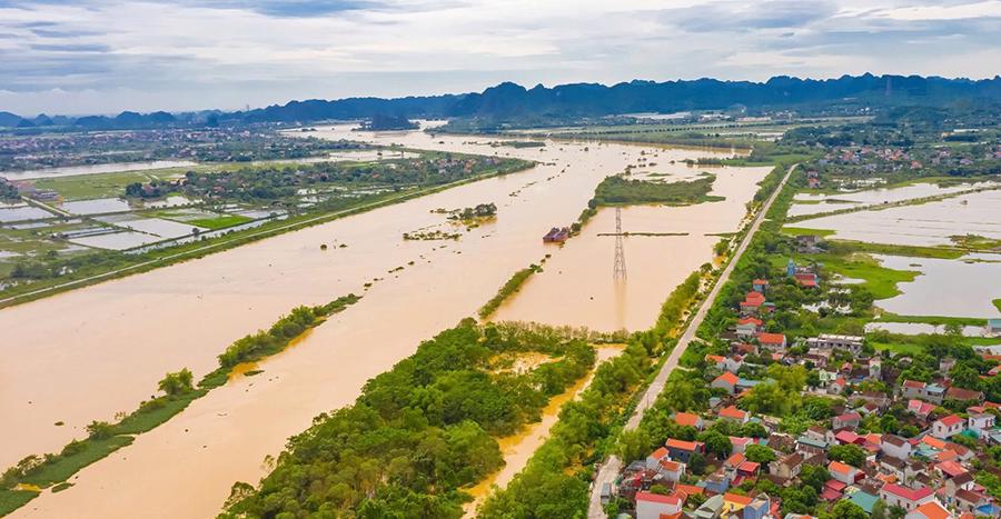
In Thanh Hoa province, according to the latest flood warning on September 10, 2024, by the Thanh Hoa Hydro-Meteorological Station, floodwaters in the rivers are changing slowly and remain at high levels. As of 7 a.m. on September 10, the water levels in the upper reaches of the Ma and Buoi Rivers were above the alert level 1, especially at the Muong Lat station on alert level 2. The lower reaches of the rivers were below alert level 1.
Specifically: On the Ma River at the Muong Lat station, the water level was 171.70 m, 0.2 m above alert level 2; at the Hoi Xuan station, it was 61.12 m, 0.88 m below alert level 2; at the Cam Thuy station, it was 17.97 m, 0.47 m above alert level 1; at the Ly Nhan station, it was 8.83 m, 0.67 m below alert level 1; at the Giang station, it was 2.86 m, 1.14 m below alert level 1. On the Buoi River, at the Thach Quang station, the water level was 13.76 m, 0.24 m below alert level 1; at the Kim Tan station, it was 10.69 m, 0.31 m below alert level 2. On the Len River, at the Len station, the water level was 3.62 m, 0.38 m below alert level 1; at the Cu Thon station, it was 2.94 m, just 0.06 m below alert level 2. On the Cau Chay River, at the Xuan Vinh station, the water level was 7.24 m, 0.76 m below alert level 1.
In the next 12 hours, the floods in the rivers are expected to remain high. Water levels in the upper reaches of the Ma River will fluctuate between alert levels 1 and 2, while the lower reaches of the Ma River, Len River, and Cau Chay River will remain below alert level 1. There is a very high risk of flash floods, landslides, and mountain floods, as well as flooding in low-lying areas, riverine areas, urban areas, and transportation underpasses.
At 10 a.m. on September 10, the Steering Committee for Natural Disaster Prevention, Search and Rescue, and Civil Defense of Thanh Hoa province continued to issue Dispatch No. 10, issuing a Level II alert on the Buoi River at Kim Tan.
The Steering Committee for Natural Disaster Prevention, Search and Rescue, and Civil Defense of Thanh Hoa province requested the People’s Committees of Thach Thanh and Vinh Loc districts to immediately deploy patrols and guards along the dykes according to the alert levels. Organize inspections and have a plan to ensure the safety of dyke works, especially the vulnerable dyke sections and culverts in the area. Proactively deploy plans to evacuate people living in riverbank areas.
Organize 24/24-hour duty shifts, closely monitor the evolution of floods and be ready to handle any situation from the outset; inform and report promptly to the Permanent Office of the Provincial Steering Committee for Natural Disaster Prevention and the Permanent Office of the Provincial Steering Committee for Civil Defense, Response to Natural Disasters and Search and Rescue.
Earlier, on the evening of September 8, the Steering Committee for Natural Disaster Prevention, Search and Rescue, and Civil Defense of Thanh Hoa province also issued a dispatch issuing a Level II alert on the Buoi River. The following day, the floodwaters gradually receded. However, as of this morning, the sudden influx of floodwaters from the upper reaches in Hoa Binh province caused the water levels to rise again, and Thach Thanh district has been evacuating households safely from the banks of the Buoi River.
In Ninh Binh province, according to the Ninh Binh Hydro-Meteorological Station, floods on the Hoang Long River at Ben De and the Day River at Ninh Binh are rising. As of 6 a.m. on September 10, 2024, the water level at Ben De was 3.5 m (at alert level 2), and at Ninh Binh on the Day River, it was 2.89 m (0.11 m below alert level 2).
In the next 12-24 hours, the water level on the Hoang Long River at Ben De is expected to continue rising. At 6 a.m. today, the water level at Ben De reached 3.5 m, which is the alert level 2. The peak is expected to reach alert level 3 (alert level 3: 4 m) at 1 p.m. on September 10, 2024.
On the Day River at Ninh Binh, the water level will continue to rise slowly, reaching 2.98 m at 6 a.m. today, below alert level 2. It is likely to reach its first peak at 1 p.m. on September 10, 2024, close to alert level 3 (alert level 3: 3.5 m). The risk of natural disasters due to flooding is at level 2.
With the above water levels, agencies have warned of the risk of flooding and the possibility of other natural disasters such as: High river water levels combined with heavy local rainfall increase the risk of flooding in low-lying areas along the river, and in low-lying areas in Nho Quan, Gia Vien, and Ninh Binh city. Flash floods, landslides, and rockslides are possible in mountainous and sloping areas in Nho Quan, Hoa Lu, and Tam Diep city.
The impact of the rising river water levels, combined with heavy rainfall, poses a high risk of flash floods, landslides, and rockslides in mountainous areas, flooding in riverside and midstream areas, and widespread low-lying areas. This could affect the safety of dikes, agricultural production, aquaculture, and residential areas, endangering the lives and property of the people, and disrupting socio-economic activities.
The Industry Unites: Responding to Northern Floods

In the coming days, the northern mountainous and midland regions of Vietnam are expected to experience heavy rainfall, with totals ranging from 100 to 200 mm, and even exceeding 350 mm in some areas. This extreme weather conditions pose a significant threat of flash floods, landslides, and localized flooding in low-lying areas. The potential for large-scale flooding, mudslides, and landslides is extremely high, and residents in these regions should prepare for potential disasters and remain vigilant.
The Red River Floods: High Waters Threaten Hanoi with Devastating Floods

The Hong (Red) River is swelling, and with the heavy rain, the National Center for Hydro-Meteorological Forecasting has issued a flood warning for Hanoi on the morning of September 10, 2024. Many inner-city streets are at risk of flooding, with water levels expected to reach depths of 10-20 cm in many areas, and some streets may experience depths of over 25 cm.
Deadly Landslides and Floods Claim Hundreds of Lives

As of 7 a.m. on September 11, 2024, the reported damage caused by Typhoon No. 3 and the subsequent flood and rain included over 200 casualties, with 141 confirmed deaths and a minimum of 59 missing persons, according to the Department of Dyke Management and Disaster Prevention (Ministry of Agriculture and Rural Development).
Landslide and Flash Flood Risk in Northern Mountainous Regions, Thanh Hoa and Nghe An at a Critical Level

According to Mr. Mai Van Khiem, Director of the National Hydro-Meteorological Forecasting Center, heavy rainfall, concentrated over a short period, poses a particular threat of flash floods and landslides in the mountainous and midland areas of the North, Thanh Hoa, and Nghe An provinces from the night of September 6 to September 8.


