In the Con Co Island, Quang Tri Province, strong winds of level 6 have been recorded, with gusts reaching level 7. As of 4 a.m., the storm’s eye was located at approximately 17.3 degrees north latitude and 109.8 degrees east longitude, about 210 km northeast of Danang and 260 km east of Quang Tri. The strongest winds recorded near the storm’s eye were of level 8, with gusts reaching level 10. The storm is primarily moving in a westward direction at a speed of about 20 km/h.
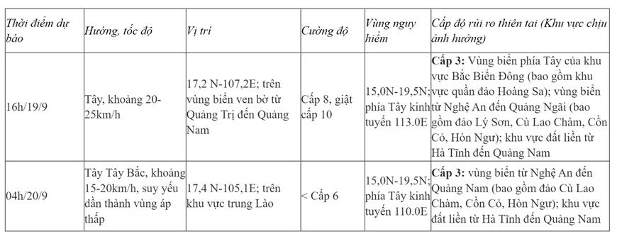
By 4 p.m. on September 19, the storm is predicted to move westward at a speed of 20-25 km/h. Its eye will likely be located at around 17.2 degrees north latitude and 107.2 degrees east longitude, with winds of level 8 and gusts of level 10. The affected areas include the western part of the northern East Vietnam Sea (including the Hoang Sa Archipelago), the sea from Nghe An to Quang Ngai Province (encompassing Ly Son Island, Cu Lao Cham, Con Co Island, and Hon Ngu Island), and the mainland from Ha Tinh to Quang Nam Province. The risk of natural disasters is rated as level 3.
By 4 a.m. on September 20, the storm is expected to move west-northwest at a slower speed of 10-15 km/h, making landfall and gradually weakening into a tropical depression. Its position is forecast to be approximately 17.4 degrees north latitude and 105.1 degrees east longitude, over central Laos, with winds of level 6. The affected areas include the sea from Nghe An to Quang Nam Province (including Cu Lao Cham, Con Co, and Hon Ngu Islands) and the mainland from Ha Tinh to Quang Nam Province. The risk of natural disasters remains at level 3.
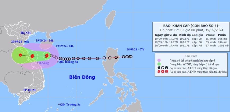
Due to the impact of the fourth storm, the western area of the northern East Vietnam Sea (including the Hoang Sa Archipelago) and the sea from Nghe An to Quang Ngai Province (including Ly Son Island, Cu Lao Cham, Con Co Island, and Hon Ngu Island) will experience strong winds of levels 6-7, with waves reaching 2.0-4.0 meters in height. Near the path of the storm’s eye, winds will reach level 8, with gusts of up to level 10, and waves can be as high as 3.0-5.0 meters. The sea conditions will be very rough.
Additionally, due to the influence of the active southwest monsoon, the sea area from Binh Dinh to Ca Mau and the southern part of the central East Vietnam Sea, as well as the southern East Vietnam Sea (including the Spratly Islands), will experience strong southwest winds of level 6, occasionally reaching level 7, with gusts of up to levels 8-9. Waves in these areas are expected to be high, ranging from 3.0 to 5.0 meters. Rough sea conditions are expected.
Coastal areas from Quang Binh to Quang Nam should be cautious of storm surges of 0.3-0.5 meters, combined with high tides and large waves, which may cause coastal erosion and flooding in low-lying areas.
All vessels operating in the aforementioned dangerous areas are at risk of being affected by thunderstorms, squalls, strong winds, and high waves.
On the mainland, from the morning of September 19, coastal areas from Ha Tinh to Quang Nam will experience increasing winds of levels 6-7, with winds near the path of the storm’s eye reaching level 8 and gusts of level 10. Even inland areas can expect gusts of levels 6-7. Be cautious of strong thunderstorms ahead of the storm’s circulation. In such weather conditions, strong winds may cause damage to trees, roofs, and advertising signs.
From September 19 to 20, the North Central and Central Central regions can expect heavy to very heavy rainfall, with average rainfall ranging from 100 to 300 mm, and even exceeding 500 mm in some localized areas. Be prepared for intense rainfall (>150 mm/6 hours) in the Quang Tri – Danang area on September 19.
On September 19, the Central Highlands and Southern regions will experience moderate to heavy rain and thunderstorms, with localized very heavy rainfall in some places. The expected rainfall in these regions is between 20 and 40 mm, with some areas receiving more than 70 mm.
Heavy rainfall may cause urban flooding in densely populated areas due to the inability of drainage systems to cope with the water volume.
The Storm’s Fury: How Strong Winds and Heavy Rains Caused Havoc in Thanh Hóa and Nghệ An Provinces

“Super Typhoon No. 4 battered two provinces on September 19, bringing heavy rainfall and strong winds that caused extensive damage and injuries. The storm’s ferocious winds led to several accidents, with large trees snapping and crashing, injuring multiple individuals and resulting in significant property damage.”
The Great Northern Dams: A Delicate Dance with Nature as Storm No.4 Approaches Vietnam.

As reported by the Vietnam Electricity (EVN), several hydroelectric reservoirs continued to discharge water for regulation up until 5 PM on September 17th. These reservoirs include Thác Bà (discharging from 2 gates), Trung Sơn (3 gates), and Bản Vẽ (2 gates).
The Central Coast Braces for Impending Tropical Storm

As per the Prime Minister’s directive, the central provinces have issued urgent communications to prepare for a possible tropical depression, which may intensify into a storm over the East Sea.
Who Donated 1.04 Billion VND and Topped the Vietnam Fatherland Front’s List?

This is only the first phase of the donation process from this organization, and we can’t wait to see the impact it will have. With their continued support, we’re confident that we can make a real difference. Stay tuned for more updates on this exciting partnership!
‘Beating the Sun and Rain, Unfazed by Wind and Storm’: Achieving the 3,000-km Expressway Goal

The Prime Minister has urged the Ministry of Transport and local authorities to continue embracing the spirit of “surmounting the sun and conquering the rain, never losing to the wind and storms”. By being proactive in dealing with adverse weather conditions, they aim to complete 3,000 kilometers of expressways by 2025.


