
Ho Chi Minh City: A Vision for the Future
With the approved plan, Ho Chi Minh City envisions becoming a global city by 2060, known for its civility, modernity, and compassion. The city aims to match the development level of major cities worldwide and serve as Asia’s economic, financial, and service hub. As a growth pole and driving force, it will propel the southern region and the entire country forward.
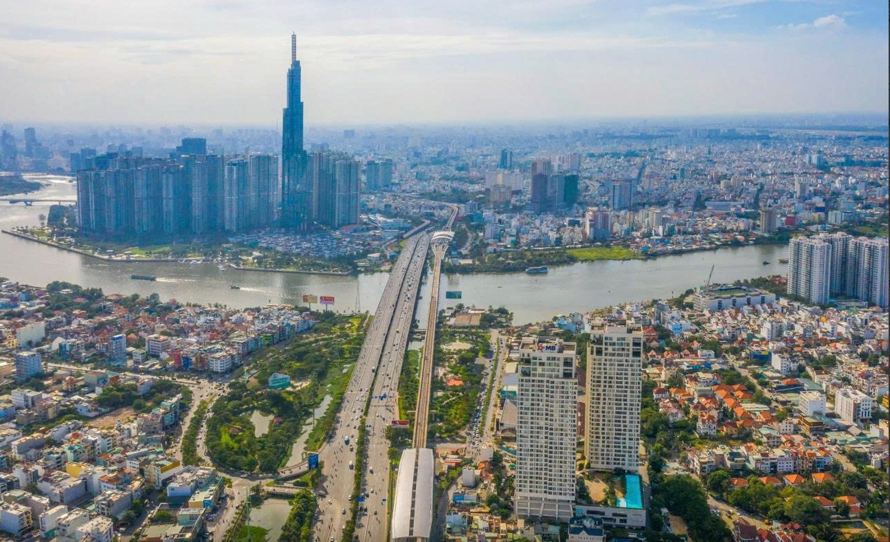
Approved Adjustment of Ho Chi Minh City’s Master Plan until 2040, with a vision towards 2060
The city’s urban development goals focus on fostering creativity and high interactivity, coupled with knowledge-based and high-tech economic growth, to enhance socio-economic development. Forming dynamic zones will enhance the city’s role as a regional and national growth center.
Ho Chi Minh City will serve as a vital transportation and digital infrastructure hub in the Southeast region, nationally and internationally. It will be a regional link and a multimodal transport hub for the Southern Key Economic Region. The city also holds a strategically important position regarding national defense and security in the Eastern Southern region and the entire country.
The adjusted master plan for Ho Chi Minh City, with a vision towards 2060, forecasts a population of 11-13.7 million by 2030 and 14-16.5 million by 2040.
In terms of spatial development orientation, the city will adopt a multi-center urban model, forming multifunctional urban subdivisions with key areas focusing on finance, commerce, tourism, culture, sports, research, education, and high-tech production. This approach will boost interactivity in socio-economic activities and foster interconnected development.
Urban space development will be closely linked to the establishment of a public transport system, providing convenient connections to the national and international transportation network, thus creating urban economic development corridors.
The city’s spatial structure will comprise six subdivisions: the central subdivision and the eastern, western, northern, southern, and southeastern subdivisions. Each subdivision will be multifunctional, associated with key development areas that serve as regional, national, and international centers, offering high-quality employment opportunities and living environments. The organization of space within these subdivisions will be closely tied to the public transport system.
Regarding spatial axes and development corridors, the plan inherits the content of the adjusted master plan for Ho Chi Minh City’s construction until 2025, continuing the city’s development in four directions: east, south towards the sea, northwest, and west-southwest. Additionally, the plan proposes the development of spatial axes, including four north-south axes and five east-west axes, and the formation of new development corridors along the Saigon River and the coastal economic zone.
The development along the Saigon River will transform the riverfront into the city’s prime urban space. The traditional riverfront areas will be developed into a unique, central urban destination, showcasing the city’s distinct character and integrating the river’s landscape with its historical formation. A public park strip will be established along the river, featuring a continuous bike and pedestrian path connecting various urban spaces and ensuring access to riverfront amenities and services.
As for the coastal economic zone, the plan involves organizing an inter-regional transportation system, connecting the city’s southern coastal areas with neighboring provinces and linking key maritime economic centers such as the international transshipment port, coastal urban tourism, technology, and eco-tourism areas, as well as the Can Gio Mangrove Biosphere Reserve.
Six Subdivisions:
1- Central Urban Subdivision (area within Ring Road 2 and north of Kenh Doi and Kenh Te)
2- Eastern Subdivision (current Thu Duc City, envisioned to become the Thu Duc Urban Subdivision)
3- Western Subdivision (including the area north of the central subdivision and a part of the southern area – the portion west of Can Giuoc River in Binh Chanh District and the part west of National Highway 1 in Binh Tan District, envisioned to become the Binh Chanh Urban Subdivision)
4- Northern Subdivision (including Cu Chi, Hoc Mon, and the part north of National Highway 1 in District 12, envisioned to become the Cu Chi – Hoc Mon Urban Subdivision)
5- Southern Subdivision (including the area south of Kenh Doi in District 8, the area east of Can Giuoc River in Binh Chanh District, District 7, and Nha Be District, envisioned to become the District 7 – Nha Be Urban Subdivision)
6- Southeastern Subdivision (including the entire Can Gio District, envisioned to become the Can Gio Urban Subdivision)
The Rise of Commercial Townhouses in Ho Chi Minh City: Unveiling the Reasons Behind the Steady Price Increase

The commercial shophouse (combined living and business) in Ho Chi Minh City has seen a faster rate of appreciation compared to regular shophouses. As a result, this type of property has become a favored investment choice for those with strong financial backing.
The Birth of a Mega-Metropolis: How the Merger of Ho Chi Minh City, Binh Duong, and Ba Ria-Vung Tau Creates a Powerhouse Benefitting the Industrial Park Baron of Binh Duong

“The proposed merger of Binh Duong, Ba Ria-Vung Tau, and Ho Chi Minh City is expected to provide a significant boost to the recovery of the Binh Duong real estate market, according to VCBS. This strategic move is anticipated to create a ripple effect, revitalizing the region’s property sector and presenting lucrative opportunities for investors and developers alike.”
Unannounced Inspection at Kim Bien Market

The authorities conducted surprise and regular inspections of Kim Bien Market to prevent hazardous chemicals from posing a threat to public safety.
The New Face of Ho Chi Minh City: 62 Streets Get a Makeover

The Ho Chi Minh City Department of Culture, Sports, and Tourism has initiated a public consultation process to gather feedback from the community regarding the naming and route adjustments of 69 roads within the city.
Presenting to the National Assembly: The Ho Chi Minh City Ring Road 4 Project: A Visionary Investment of Over VND 120,000 Billion.

The Ho Chi Minh City Ring Road No. 4 project is slated to commence construction this year and is expected to be completed by 2029. This ambitious infrastructure undertaking promises to revolutionize transportation in the region, offering a strategic route that will enhance connectivity and facilitate seamless travel. With a projected length of approximately 210 kilometers, this highway will encircle the city, providing a vital link between neighboring provinces and playing a pivotal role in decongesting the metropolis.


