


: Returning to Critical Support Levels?")


: A Wave of Negativity Sweeps In")
Deputy Chairman of the Hanoi People’s Committee, Duong Duc Tuan, has signed a decision assigning the task of planning two urban sub-zones, E5-1A and E5-1B, at a scale of 1:2,000.
These sub-zones are located at the northeastern gateway of the capital, spanning Dong Anh and Phu Dong communes. The planning area is bordered by key regions: to the north, it adjoins the urban sub-zone of Thu Lam commune; to the southwest, it follows the Duong River dyke; to the southeast, it connects to the eastern expansion of the central urban area; to the northwest, it borders sub-zones XB-2 and E2-4; and to the northeast, it meets Ring Road 3 and Bac Ninh Province, where the Gia Binh Airport is being promoted with an investment of nearly VND 200 trillion.
The total planning area covers approximately 3,300 hectares, with an expected population of 220,000 to 230,000 by 2045.
According to the development plan, this area will become an extension of the central urban area, serving as Hanoi’s northeastern gateway with a modern, synchronized infrastructure system and strong connectivity to surrounding rural areas.
The sub-zone planning project is expected to allocate diverse land uses, including residential, mixed-use, urban-level public facilities, high schools, green spaces, technical infrastructure, cultural and sports centers, educational institutions, healthcare, religious and historical sites, security areas, water bodies, and transportation networks. Notably, a portion of the area will be developed following the Transit-Oriented Development (TOD) model, leveraging transportation advantages to form a new urban axis.
This area is projected to become a high-quality logistics and trade hub, serving the coastal economic corridor while effectively utilizing the national railway system and inland waterways. Regional science and technology research centers, high-quality educational institutions, advanced healthcare complexes, international-standard entertainment centers, and themed parks will also be established, creating a new focal point for Hanoi’s northeastern gateway.
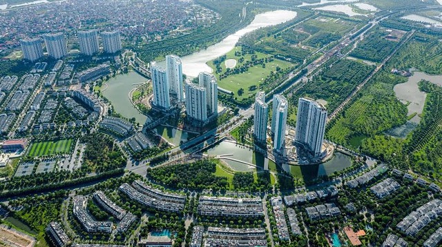
To the northeast, the project borders Ring Road 3 and Bac Ninh Province, where the Gia Binh Airport is being promoted with an investment of nearly VND 200 trillion (Illustrative image).
Alongside the planning of sub-zones E5-1A and E5-1B, on November 13, during the 27th Specialized Session, the Hanoi People’s Council approved the investment policy for the Project to Construct the Road Connecting Gia Binh Airport to Hanoi Capital. The project spans approximately 14 km, passing through Thuan An, Phu Dong, Thu Lam, and Dong Anh communes in Hanoi, as well as Tu Son and Phu Khe wards in Bac Ninh Province.
Proposed by Sun Group Joint Stock Company, the project will be implemented under a Public-Private Partnership (PPP) model, specifically a Build-Transfer (BT) contract. The land fund for investor compensation, approximately 405 hectares, will be allocated in Dong Anh and Phu Dong communes within the planned E5-1A+E5-1B sub-zones.
Regarding Gia Binh Airport, on November 14, the Government submitted the investment policy to the National Assembly. According to the environmental impact assessment report published by Masterise Group in November 2025, Gia Binh Airport will utilize nearly 1,885 hectares of land in Gia Binh, Luong Tai, Lam Thao, and Nhan Thang communes.
The total investment for the project is estimated at VND 196.378 trillion across two phases, with VND 141.236 trillion required for the first phase. Gia Binh International Airport will meet 4F standards, serving 30 million passengers and 1.6 million tons of cargo by 2030; by 2050, capacity will increase to 50 million passengers and 2.5 million tons of cargo annually.
Gia Binh Airport aims to achieve a 5-star international service standard, ranking among the world’s top 10 airports according to Skytrax criteria and earning an Airport Service Quality (ASQ) award from the Airport Council International (ACI). This project is envisioned as the northern region’s aviation gateway, a hub for passenger and cargo transit, and a maintenance, repair, and overhaul (MRO) center for the Asia-Pacific region.
Vietnam’s TOD Urban Revolution: Unlocking the Potential of Next-Gen Megacities

The Transit-Oriented Development (TOD) model is an essential strategy for creating modern, sustainable living spaces and addressing land scarcity in major urban areas, particularly in Ho Chi Minh City. By integrating urban development with public transportation, TOD fosters efficient land use, reduces congestion, and enhances quality of life, making it a cornerstone for future-proof cities.
Upcoming Launch of Hanoi’s Mega Project: The Red River Scenic Boulevard Axis Spanning 16 Wards and Communes

Unveiling Hanoi’s transformative vision: the Red River Scenic Avenue megaproject is set to commence, featuring a 92-kilometer main road with 4-6 lanes, stretching from Hong Ha Bridge to Me So Bridge, seamlessly traversing 16 wards and communes.
Institutions – Infrastructure – Human Resources: The Three Pillars Driving Ho Chi Minh City’s Development from 2025 to 2030

To implement the resolutions of the 1st Party Congress of Ho Chi Minh City, the City Party Committee has developed an action program comprising 10 task groups and 3 breakthrough priority programs.
Revitalizing Railroads: Seizing the Opportunity to Restore Economic Prominence

After years of stagnation, Vietnam’s railway sector is poised for a transformative era with the North-South high-speed line and a wave of new projects. The greatest challenge now lies not in “adding more routes,” but in untangling the institutional, financial, and governance bottlenecks that have long stifled the industry’s growth.
Proposed 338 Trillion VND Hong River Scenic Boulevard by Deo Ca – Van Phu – MIK – Dai Quang Minh Consortium

The Red River Landscape Avenue project, proposed by the consortium of Deo Ca – Van Phu – MIK – Dai Quang Minh, encompasses two urban expressways, a monorail system, and a scenic park. This ambitious initiative is estimated to require a total investment of 338 trillion VND.


