


: Mixed Signals Emerge")

: Short-Term Outlook Continues to Deteriorate")
As of 7 a.m. today (November 26), the eye of the storm was approximately 440 km east of Song Tu Tay Island. The strongest winds near the storm’s center reached level 8 (62-74 km/h), with gusts up to level 10.
Forecasts indicate that throughout the day and night of November 26, the storm will move rapidly in a west-northwest direction at a speed of 15-20 km per hour, continuing to intensify. By 7 a.m. on November 27, the storm’s center will be about 170 km north of Song Tu Tay Island, strengthening to level 10 with gusts up to level 13.
On November 27, the storm will shift to a west-southwest direction, slowing to 5-10 km per hour and gaining strength. By 7 a.m. on November 28, when approximately 160 km northwest of Song Tu Tay Island, the storm is expected to reach level 11, with gusts up to level 14.
According to the National Center for Hydro-Meteorological Forecasting, starting November 28, as the storm approaches the 113th meridian, it will be influenced by various factors such as a weakening subtropical high-pressure system and a low-pressure trough in the westerly wind belt at 5000 meters. These factors may alter the storm’s path. The subsequent trajectory of Storm 15 remains highly uncertain, with significant variations among international meteorological models and agencies.
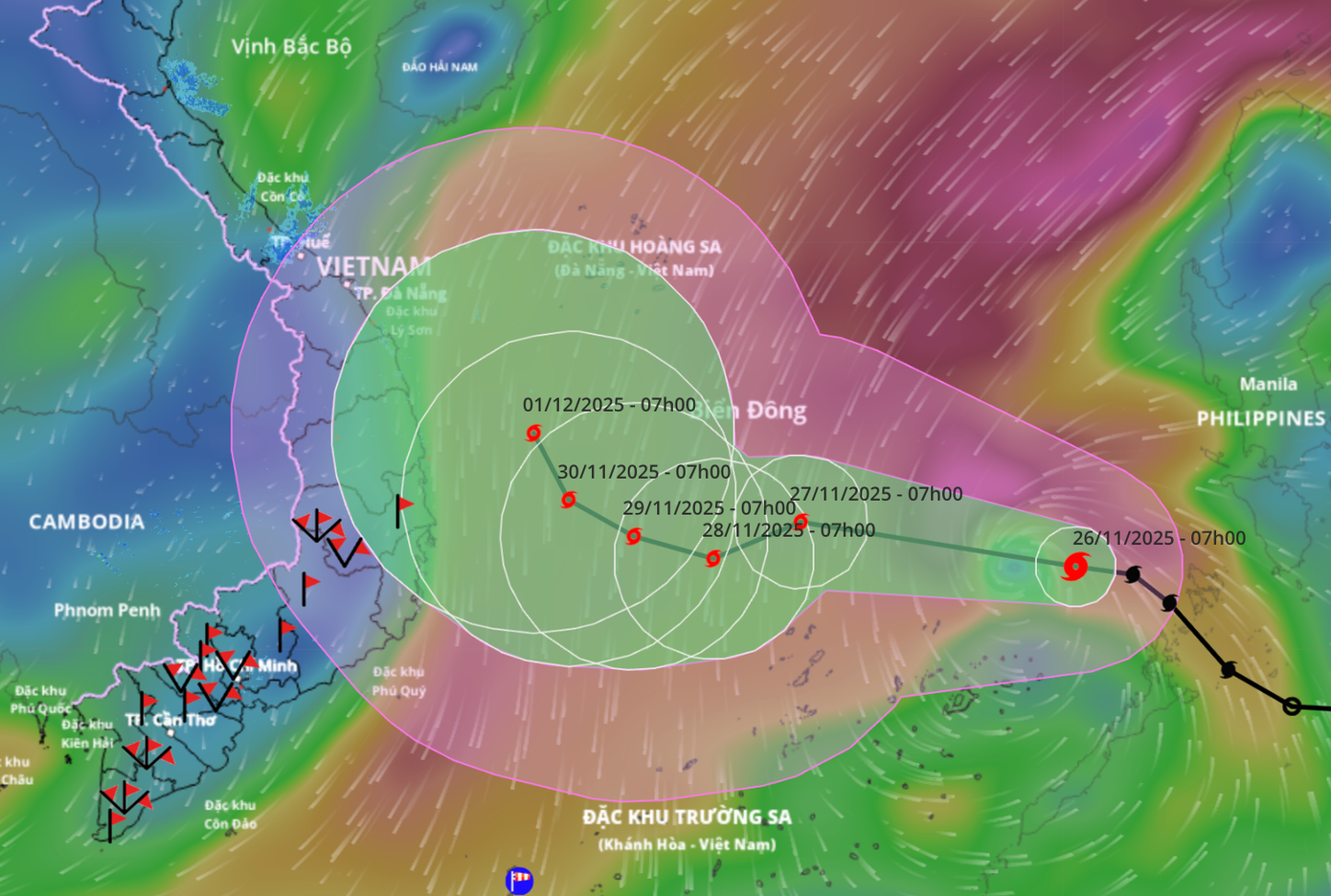
Latest forecast on the path of Storm 15.
The National Center for Hydro-Meteorological Forecasting presents two possible scenarios for Storm 15.
The most likely scenario is that the storm will shift northward upon reaching the Northwest waters of the Truong Sa archipelago (about 500 km east of the Gia Lai-Khanh Hoa coast), gradually weakening into a low-pressure area. This low-pressure area may drift toward the mainland of central provinces.
In this scenario, the mainland is less likely to experience storm-force winds, but widespread rain may occur from Da Nang to Lam Dong in early December. Rainfall amounts will be lower than the extreme rainfall event from November 16-21.
A less likely but more severe scenario is that the storm will not change direction and will make landfall in the Gia Lai-Khanh Hoa area.
Under this scenario, the storm will reach its peak intensity of level 11, with gusts up to level 13, in the northern part of the Truong Sa archipelago. It will then move westward toward the mainland of central provinces, primarily Gia Lai-Khanh Hoa, weakening to level 8 or a tropical depression.
In this case, coastal areas from Da Nang to Lam Dong will experience strong winds of level 8, with gusts up to level 10, and high waves of 3-5 meters, causing rough seas. Heavy rainfall, ranging from 150-250 mm, may occur from November 29 to December 1.
In the immediate future, the Mid-East Sea area, including the northern waters of the Truong Sa archipelago, will face strong winds of level 6-7, with level 8-10 winds and gusts up to level 13 near the storm’s center. Waves will reach 4-6 meters, and up to 6-8 meters near the storm’s center, with very rough seas.
From November 27-28, the Mid-East Sea area, including the northern waters of the Truong Sa archipelago, may experience winds of level 11, with gusts up to level 14, and waves of 7-9 meters, leading to extremely rough seas.
The National Center for Hydro-Meteorological Forecasting warns that the storm’s evolution remains highly complex. Continuous updates on the latest forecasts are essential to proactively prepare and respond to potential impacts.


