Focusing Primarily on Small Hydropower
After more than two decades of robust development, Vietnam’s hydropower system boasts over 270 plants with a total capacity of approximately 24,900 MW, contributing around 30% of the annual electricity output. However, the operational model, heavily reliant on rainfall and flooding patterns, is now facing a stark reality: climate change is making weather conditions increasingly extreme and unpredictable. This has compelled the power sector to adopt a more adaptive, flexible, and data-driven operational approach.
Within the total capacity of 24,900 MW, large hydropower plants (over 30 MW) account for nearly 90%, primarily located in the Northwest and North Central regions. In contrast, the Central Highlands and Western Highlands, characterized by steep, short, and fast-flowing rivers, host only a small portion of large plants. The majority here are small, dispersed hydropower stations along the highland rivers.
On the Sê San basin, the Upper Kon Tum chain with a capacity of around 220 MW, Plei Krông at 100 MW, Ialy at 720 MW, Sesan 3 at 260 MW, and Sesan 4 at approximately 360 MW, form the backbone of the power system in the Northern Central Highlands.
Further downstream, the Sê Rêpok system creates a continuous chain of projects, including Sê Rêpok 3, Sê Rêpok 4, Buôn Tua Srah, and Buôn Kuốp—the largest in this cluster with a capacity of 280 MW—interspersed with Drây H’Linh.
In the Ba River basin, the Ayun Hạ, Krông H’Năng, Sông Ba Hạ, and Sông Hinh hydropower plants constitute the main energy line of the Southern Central Highlands. Among these, Sông Ba Hạ stands as the largest complex in the region with a capacity of 220 MW.

Most hydropower plants in the Central Highlands and South Central Coast have small capacities.
Along the Truong Son mountain range, the mountain-side hydropower system continues with A Vương, Đăk Mi 4—with capacities ranging from 190 to 264 MW depending on the phase—Sông Bung 2, Sông Bung 4, and Sông Tranh 2 at 190 MW, before the water reaches the Hương Điền – Bình Điền – Tả Trạch reservoir chain in Thua Thien Hue province.
The rivers in the Central Highlands and Central regions are short, steep, and fast-flowing along a west-east axis. Consequently, the hydropower reservoirs are located at higher elevations, each holding hundreds of millions of cubic meters of water. When releasing water, the flow rushes downstream rapidly, exerting significant pressure on the lower regions and often causing severe flooding. Notably, most reservoirs in the Central Highlands, including those in Lam Dong, are constructed in a cascading manner within the same basin. When an upstream reservoir releases water, the downstream ones are forced to open their gates, leading to a cumulative effect where floodwaters pile up, creating a “flood on top of a flood” situation.
Expert Nguyen Huy Hoach from the Vietnam Energy Association notes that the recent rainfall and flooding following Typhoon No. 14 clearly highlight the differences in flood control capabilities among cascading reservoir systems. Some reservoirs with substantial flood control capacities effectively reduce and mitigate flooding. However, others, primarily designed for power generation, have limited flood control capabilities and must release water downstream at rates matching the inflow to ensure the safety of the structures.
For instance, in the Ba River basin, the cascading system includes Ayun Hạ, Krông H’Năng, Sông Ba Hạ, and the Sông Hinh hydropower plant on a major tributary. The flood control capacities of these reservoirs are limited, as their primary function remains power generation. During Typhoon No. 14, the rapid influx of water into the Sông Ba Hạ reservoir exceeded its retention capacity, forcing the plant to release water downstream at nearly the same rate as the inflow. Since Sông Ba Hạ is not a dedicated flood control reservoir, at its peak, the discharge rate reached 16,100 m³/s, causing deep flooding in Phu Hoa, Dong Hoa, and Son Hoa districts and severing transportation links in many areas.
Adjusting Inter-Reservoir Operation Procedures in December
In an interview with Tien Phong, a leader from the Department of Industrial Safety and Environmental Technology under the Ministry of Industry and Trade stated that a working group from the ministry recently inspected four reservoirs in Lam Dong but did not include the Sông Ba Hạ hydropower plant. This plant operates under procedures approved by the provincial People’s Committee Chair and follows directives from the Civil Defense Command and the provincial Chair during flooding events.
“All reports submitted to the Ministry confirm that Sông Ba Hạ operated in accordance with the procedures and the province’s directives,” the leader of the Department of Industrial Safety and Environmental Technology stated.
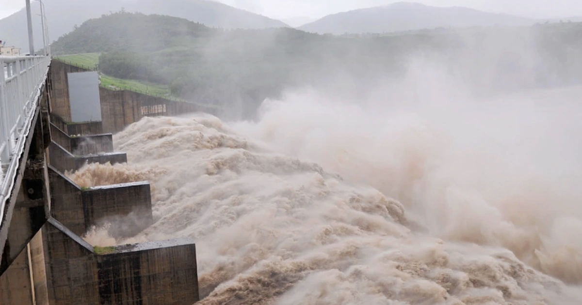
Sông Ba Hạ hydropower plant released record amounts of water during the late November flooding.
According to the leader, from a technical standpoint, when flooding exceeds historical levels and persists for several days, even reservoirs with flood control functions can only mitigate the impact for a short period. Once the reservoir reaches capacity, it must switch to ensuring the safety of the structure, releasing water at the same rate as the inflow. The law prioritizes structural safety above all else. If the structure fails, the consequences would be far more severe.
“In the recent situation, the provincial Chair allowed Sông Ba Hạ to store water above the normal flood level up to the reinforced flood level to reduce downstream flooding—effectively holding back an additional 60 million m³ of water. However, for accuracy, an official report from the unit is needed,” the leader explained.
Addressing the current shortcomings in inter-reservoir operation procedures, the leader of the Department of Industrial Safety and Environmental Technology noted that these procedures were approved between 2018 and 2019. In recent years, extreme weather events have increasingly exceeded the scenarios anticipated in the procedures.
“The Prime Minister has tasked the Ministry of Agriculture and Rural Development with coordinating with the Ministry of Industry and Trade to review and adjust these procedures. We are currently working on this and expect to complete it by December. Moving forward, we may consider allowing provincial Chairs to set lower flood preparation water levels to minimize downstream damage. However, accurate forecasting is a critical prerequisite,” the leader concluded.
The Plight of the World’s 4th Largest Economy: Rice Prices Surge Over 50% in a Year, Crippling Key Industries

In this Asian nation, farmers are increasingly abandoning rice cultivation in favor of more profitable crops.


