


: Returning to Critical Support Levels?")


Update: Flooding is currently occurring on the Cau River (Bac Ninh), Thuong River (Bac Giang), Thai Binh River (Hai Duong), and Hong River (Hanoi), with water levels rising.
Flood waters on the Thao River in Yen Bai are receding, while in Phu Tho, they are slowly changing. Flooding on the Lo River (Tuyen Quang, Phu Tho) peaked at 27.73 meters, 1.73 meters above the warning level 3 at 5 am on 9/11 and are slowly receding. Water levels on the Hoang Long River (Ninh Binh) are also slowly changing. The Luc Nam River (Bac Giang) is experiencing a decrease in water levels.
Specifically, at 7 am on 9/11, the water level on the Thao River in Yen Bai was at 34.51 meters, 2.51 meters above warning level 3, and 0.09 meters above the historical flood level of 34.42 meters in 1968. In Phu Tho, the water level was at 18.33 meters, 0.13 meters above warning level 2.
On the Cau River at Dap Cau, the water level was recorded at 7.20 meters, 0.90 meters above warning level 3. The Thuong River at Phu Lang Thuong recorded a water level of 7.09 meters, 0.79 meters above warning level 3. The Luc Nam River at Luc Nam was at 6.04 meters, 0.26 meters below warning level 3.
The Lo River at Tuyen Quang and Vu Quang recorded water levels of 27.72 meters and 21.01 meters, respectively, with both readings 1.72 meters and 0.51 meters above warning level 3.
On the Hoang Long River at Ben De, the water level was 4.47 meters, 0.47 meters above warning level 3. The Thai Binh River at Pha Lai recorded a water level of 5.83 meters, 0.17 meters below warning level 3.
The Hong River in Hanoi reached 10.86 meters, 0.36 meters above warning level 2.
In the next 12 hours, the Thao River in Yen Bai is expected to continue receding but remain above warning level 3. In Phu Tho, the water level will drop below warning level 2. The Lo River in Tuyen Quang and Vu Quang will also drop to warning level 3.
Flooding on the Cau River will continue to rise and remain above warning level 3. The Thuong River will change slowly, staying above warning level 3. While the Luc Nam River is receding, it will remain above warning level 2.
The Thai Binh River will continue to rise to warning level 3, and the Hoang Long River will change slowly, staying above warning level 3.
According to the National Center for Hydro-Meteorological Forecasting, the Hong River in Hanoi is expected to peak at noon on September 11, surpassing warning level 2 but remaining below warning level 3.
In the next 12-24 hours, the Thao River in Yen Bai will continue to recede to warning level 2, and in Phu Tho, it will drop to warning level 1.
The Lo River in Tuyen Quang and Vu Quang will drop to warning level 2. The Cau River at Dap Cau will change slowly, remaining above warning level 3. The Thuong River will also change slowly and stay above warning level 3.
The Luc Nam, Thai Binh, and Hoang Long Rivers will change slowly, with water levels remaining above warning levels 2 and 3, respectively. The Hong River in Hanoi will recede slowly and stay below warning level 2.
Warning for the next 12-24 hours: Water levels at downstream stations of the Hong-Thai Binh river system will rise to warning level 3 and above.
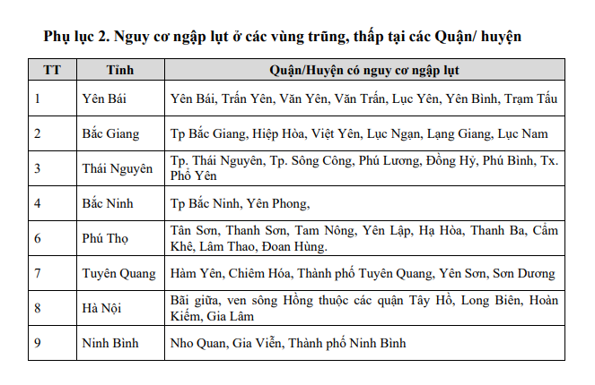
The high water levels will cause flooding in low-lying areas along the river, affecting outer dykes, embankments, and protective dikes. This will have a significant impact on vulnerable sections of the dyke, embankment, and riverside construction systems in the provinces of Hanoi, Ha Nam, Nam Dinh, Hai Duong, Hung Yen, Thai Binh, and Ninh Binh.
There is a high risk of flooding in low-lying areas along the river in the provinces of Lang Son, Cao Bang, Lao Cai, Yen Bai, Phu Tho, Bac Giang, Bac Kan, Thai Nguyen, and Hoa Binh. Landslides and flash floods are possible in mountainous areas of the Northern region.
The National Center for Hydro-Meteorological Forecasting has issued a level 3 disaster risk warning for flooding.
The impact of the floods includes inundation of low-lying areas along the river, affecting transportation, aquaculture, agriculture, and socio-economic activities, especially in the lower Hong-Thai Binh river basin.
Restoring Power to 4.8 Million Customers

As of the morning of September 11, units of the Northern Power Corporation have successfully restored power to 4.8 million customers out of the total of over 5.9 million affected by Typhoon No. 3.
The Power is Back: 3 Provinces and Cities Have Their Electricity Restored

As of September 10th, the power grid affected by Storm No. 3 in Quang Ninh province, Hai Phong city and Hai Duong province has been substantially restored. Essential services such as hospitals, communication networks and clean water supplies have had their power restored.
The Road Less Travelled: Uncovering the Beauty of the Thai Nguyen – Cho Moi Highway

The Vietnam Road Administration reports that the Thai Nguyen – Cho Moi Highway in Thai Nguyen City is currently experiencing severe flooding, with water levels reaching depths of 0.6 to 1.2 meters. This has resulted in significant traffic disruptions, and all vehicles traveling through this area have been temporarily halted.
The New Second Thang Long Bridge Expressway: A Smooth Commute or a Watery Mess?

With the Pháp Vân – Cầu Giẽ Highway submerged in deep waters from Km191 to Km192, both directions, the Traffic Police Department advises motorists, especially those with low-clearance vehicles, to refrain from traversing this stretch of the highway.
The North Endures a Deluge of Natural Disasters

As of the Ministry of Agriculture and Rural Development’s report released at 10:00 AM on September 10, 2024, the damage inflicted by the third storm, floods, and landslides stood at a grim count of 104 lives lost or missing (65 dead and 39 missing). The storm and its aftermath also left 48,337 homes damaged.


: More Extreme Than the Weather")