


: Returning to Critical Support Levels?")


: A Wave of Negativity Sweeps In")
The Hanoi People’s Committee has recently submitted a report to the Government regarding the implementation of the Hong River Scenic Boulevard investment project. This ambitious initiative is poised to become a new iconic symbol of the capital city while fostering urban development along both banks of the Hong River.
This project stands out for its immense scale, symbolic significance, and profound impact on Hanoi’s urban development in the coming years.
According to the report, the project spans approximately 11,000 hectares, with the Hong River Scenic Boulevard axis covering around 7,800 hectares. It extends across 16 administrative wards and communes, including: Thuong Cat, Dong Ngac, Phu Thuong, Hong Ha, Linh Nam, Bo De, Long Bien, O Dien, Thanh Tri, Nam Phu, Hong Van, Me Linh, Thien Loc, Vinh Thanh, Dong Anh, and Bat Trang.
The project is divided into three segments along the Hong River, each with distinct functions and development models. These segments aim to harmoniously blend nature conservation, commercial growth, tourism, and public spaces.
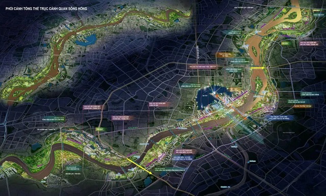
Overview of the Hong River Scenic Boulevard. Image: Hanoi Department of Construction
|
The segment from Hong Ha Bridge to Thang Long Bridge is designated as an eco-friendly park area, focusing on natural preservation, sports, and existing residential zones. This open space will seamlessly integrate nature with urban living, enhancing the capital’s landscape and environment.
The section from Thang Long Bridge to Thanh Tri Bridge will serve as a multifunctional area, encompassing existing and redeveloped residential zones, new constructions, public facilities, commercial services, themed parks (technology, culture, festivals, history, arts, entertainment), craft villages, tourism ports, and green spaces. This area will emerge as a vibrant hub for cultural, commercial, and tourism activities, revitalizing both central and suburban Hanoi.
The segment from Thanh Tri Bridge to Me So Bridge will prioritize commerce, services, transportation, eco-agricultural parks, and residential areas. It will also feature public facilities, tourism services, industrial clusters, craft villages, parks, and greenery. This section will strengthen connectivity between urban and suburban areas, fostering a cohesive infrastructure for socio-economic development.
The project’s main road is the 92-kilometer Hong River Scenic Boulevard, comprising two routes along both riverbanks, stretching from Hong Ha Bridge to Me So Bridge. The road will have 4-6 lanes, primarily running outside the dyke and avoiding existing residential areas to balance traffic development with environmental preservation.
Accompanying the boulevard are two 85-kilometer monorail lines, designed under the Transit-Oriented Development (TOD) model.
The project will also establish a network of 8 open parks, eco-parks, and 12 themed parks, covering a total of 3,297 hectares. Notable landmarks will be positioned outside the dyke, creating a green, clean, and beautiful environment that integrates tourism, sports, and entertainment.
The project is divided into three components: land clearance, construction of the Hong River Scenic Boulevard, and development of the monorail urban railway lines. The city plans to compensate investors with land funds in the project area or other locations, following a Public-Private Partnership (PPP) model.
The total investment is estimated at 338 trillion VND, with construction expected to commence on December 19 and completion targeted by 2030.
Trong Phu
– 15:28 18/11/2025
Revitalizing Railroads: Seizing the Opportunity to Restore Economic Prominence

After years of stagnation, Vietnam’s railway sector is poised for a transformative era with the North-South high-speed line and a wave of new projects. The greatest challenge now lies not in “adding more routes,” but in untangling the institutional, financial, and governance bottlenecks that have long stifled the industry’s growth.
Proposed 338 Trillion VND Hong River Scenic Boulevard by Deo Ca – Van Phu – MIK – Dai Quang Minh Consortium

The Red River Landscape Avenue project, proposed by the consortium of Deo Ca – Van Phu – MIK – Dai Quang Minh, encompasses two urban expressways, a monorail system, and a scenic park. This ambitious initiative is estimated to require a total investment of 338 trillion VND.
Becamex – VSIP – VRG Consortium Partners with Tay Ninh Province to Develop 1,500-Hectare Complex at Moc Bai Gateway

Becamex, VSIP, and VRG have jointly signed a Memorandum of Understanding (MoU) with the People’s Committee of Tay Ninh Province, marking the launch of a large-scale Industrial-Urban-Service Complex development plan in the Moc Bai area.
Ho Chi Minh City Aims to Complete 232 km Metro Network by 2030

Ho Chi Minh City aims to complete 232 kilometers of Metro by 2030. The entire political system is focused on accelerating progress, mobilizing additional resources, and expanding land funds through the Transit-Oriented Development (TOD) model.
Stunning Development: Hanoi Allocates Nearly 4,000 Hectares Near Noi Bai Airport for Urban Planning in Three Northern Real Estate Hotspots

The Hanoi People’s Committee has officially approved the planning task for the XB-5 urban subdivision, with a scale of 1:2000. The planning area spans approximately 3,971 hectares, encompassing four northern communes of the capital: Noi Bai, Quang Minh, Soc Son, and Phuc Thinh.


