
 Reports Significant Profit in Q1 2024")


According to the Provincial Planning of Thai Binh for the period 2021-2030, with a vision to 2050 that was approved by the Prime Minister on January 11, 2024, the urbanization rate of the entire province is expected to reach over 35%. The urban system of Thai Binh province consists of 25 urban areas, including 1 type I urban area, 1 type III urban area, 5 type IV urban areas, and 18 type V urban areas.
Notably, this is an increase of 5 urban areas compared to the National Urban Classification Plan for the period 2021-2030 approved by the Prime Minister in February 2021.
Specifically, the 5 new urban areas are: Thai Thuy (by 2030, it will meet the criteria for a type III urban area based on the entire Thai Thuy district); Tra Giang, Kien Xuong district (by 2030, it will meet the criteria for a type V urban area and be located within the expanded boundaries of Thai Binh city); Nam Trung, Tien Hai district (by 2020, it will meet the criteria for a type V urban area); Cong Hoa, Hong Minh, Hung Ha district (by 2030, it will meet the criteria for a type V urban area).
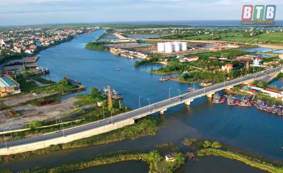
Regarding Thai Thuy, according to the draft provincial planning for the period 2021-2030, this urban area is proposed to be planned based on the entire current Thai Thuy district. This is the largest district in the province with an area of 256.4 km2, equivalent to 25,600ha, and a population density of over 1,040 people/km2. Thai Thuy district currently has Diem Dien town as a type IV urban area. The town is part of the Thai Binh Economic Zone – a key economic zone of the province with an area of over 30,500ha, including 22 industrial parks with the government’s investment incentives and the province’s investment support policies.
In addition, Thai Thuy is not only the northeast subregion of Thai Binh province, but also the central area of the Thai Binh Economic Zone closely associated with the development of industry, services, and ports of the Diem Dien and Tan Son areas.
Hong Minh new urban area is located in Hong Minh commune, south of Hung Ha district. The planned area is a comprehensive development area with multiple sectors including services, agriculture, urban and rural areas in Hung Ha district. The total natural land area is 898.39ha; the population is about 8,859 people; and the population density is 986.5 people/km2. The main economic sector is services, with an average income per capita of 46.4 million VND/person/year.
For the new Cong Hoa urban area, it is located in Cong Hoa commune, north of Hung Ha district, adjacent to Hung Yen province. This area is planned as a comprehensive development area with multiple sectors including services, agriculture, urban and rural areas in Hung Ha district. The total natural land area is 632.79ha; the population is about 7,174 people; and the population density is 1,135 people/km2. The main economic sector is services, agriculture, with an average income per capita of 42.35 million VND/person/year.
Tra Giang urban area comprises Tra Giang commune, An Binh commune, and Quoc Tuan commune, located in the northern part of Kien Xuong district. This urban area is planned as a comprehensive development area with multiple sectors including services, urban areas, and rural areas in Kien Xuong district. The total natural land area is about 19.98 km2 (1,998ha); the population is about 16,874 people; and the population density is 844.5 people/km2. The main economic sectors are services and agriculture, with an average income per capita of 41.3 million VND/person/year.
Regarding the new Nam Trung urban area, it is located in Nam Trung commune, south of Tien Hai district, planned as a comprehensive development area with multiple sectors including services, urban areas, and rural areas in Tien Hai district. The total natural land area is 786.6ha; the population is about 11,678 people; and the population density is 1,485.7 people/km2. The main economic sectors are services and agriculture.
The province of Thai Binh is a coastal province located in the Red River Delta, with a natural area of 1,534.4 km2, ranking as the 10th smallest province in Vietnam, accounting for 0.5% of the country’s total area. However, in terms of population, Thai Binh ranks 11th out of 63 provinces and cities, accounting for 1.9% of the country’s population, with a population density 4 times higher than the national average.
To the north, Thai Binh province borders Hung Yen province, Hai Duong province, and Hai Phong city. To the south, it borders Nam Dinh province; to the east, it borders the Gulf of Tonkin and the East Sea. To the west and southwest, it borders Nam Dinh province and Ha Nam province.
Thai Binh province has 8 administrative units including Thai Binh City and the districts of Dong Hung, Hung Ha, Kien Xuong, Thai Thuy, Tien Hai, Quynh Phu, and Vu Thu. In recent years, Thai Binh has been evaluated as a dynamic province with many unique potentials and competitive advantages in terms of investment environment,…


 launches into a bull race: 250 million USD about to be received from Bain Capital, “taking on” the pressure of nearly 9,000 billion USD in maturing debts in the next 12 months.")

