


: Short-Term Outlook Continues to Deteriorate")


Nha Trang is currently working on 14 detailed planning subdivisions at a scale of 1/2000, in accordance with the Approved Master Plan for Nha Trang City until 2040, as per the Government’s Decision No. 259/QD-TTg dated March 31, 2024.
Among these plans is the Detailed Planning Project at a scale of 1/2000 for the Urban – Park – New Administrative Center of Khanh Hoa Province. This project, with an area of 705.12 hectares in Vinh Thai and Phuoc Dong communes, was approved in 2012 and has since faced some challenges.
Recently, the People’s Committee of Nha Trang City has finalized the adjusted planning project for the Urban – Park – New Administrative Center of Khanh Hoa Province at a scale of 1/2000 (referred to as the New Adjusted Project) and is seeking feedback from the community.
The area covered by the new planning project is approximately 654.55 hectares, a reduction from the 2012 study area of over 700 hectares, and it falls within the communes of Vinh Thai and Phuoc Dong in Nha Trang City.
The planning area is a lowland region that receives water from the Quan Truong and Tac Rivers from the western part of Nha Trang City. Most of the area consists of aquaculture water surfaces, unused water bodies, and flower-growing land.
There are five detailed plans at a scale of 1/500 within this area, and land filling is underway for projects that have already been approved, such as the Thanh Phong Peninsula Urban Area and the VCN Eco-Urban Area.

Urban – Mangrove Park – Administrative Center of Khanh Hoa Province
The New Adjusted Project will focus on three spatial development strategies. Firstly, it aims to create an iconic administrative center that is not only grand and solemn but also accessible to visitors and locals alike.
Secondly, it will establish a green connection throughout the urban area with six islands surrounded by a network of water bodies.
Thirdly, it will enhance the value of the riverfront, strengthen water connections, and emphasize the appeal of the Quan Truong River’s frontage, with its meandering curves creating a vibrant waterfront.
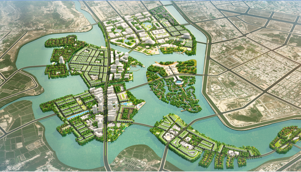
Perspective of the Urban – Park – Administrative Center of Khanh Hoa Province
The New Adjusted Project comprises six islands surrounded by water bodies. The Urban Park and the Ecological Park serve as the central green spaces for the area.
A unique feature will be the connection of the islands through park and tree-lined avenue corridors.
The plan also aims to develop green connections between the functional islands to harmoniously integrate the urban space with the natural ecosystem.

The new planning project includes six islands connected by transportation networks and bridges with north-south and east-west axes.
The land use plan for the Urban – Park – New Administrative Center includes: approximately 399.51 hectares of construction land, accounting for 61.04% of the planning area, and about 255.04 hectares of other land, accounting for 38.96% of the planning area.
A distinctive feature of this area will be the construction of ecological mangrove parks, children’s playgrounds, public sports areas, and public spaces that seamlessly blend spacious water surfaces with canal-side green spaces, enhancing aesthetic appeal and introducing a rich variety of forms and colors.
This area will also feature a system of residential green spaces, sports and recreational green spaces integrated with new community cores, and street green spaces in the form of ‘strips’ that combine shade trees with decorative plants.

System of ecological mangrove parks in the new planning project for the Urban – Park – Administrative Center of Khanh Hoa Province
The transportation orientation within this area includes Ring Road 2 with a planned width of 43m and Ring Road 3 with a width of 40m as the north-south axes.
The east-west axis is D6 Road, connecting Ring Road 2 to Ring Road 3 with a width of 35m; K6 Road, connecting Ring Road 3 to Provincial Road 3 with a planned width of 23m; and Road No. 22, connecting Ring Road 2 to Ring Road 3 with a width of 27m.

Planning of the north-south and east-west transportation systems
The new planning project is expected to accommodate a population of 49,000 and generate 9,600 cubic meters of sewage per day. Therefore, it will comply with the approved plans and ongoing projects in the area.
It will utilize a separate sewage system from the rainwater drainage system, with six sub-areas for sewage drainage. The collection network will use D300 sewage pipes to direct wastewater to centralized treatment stations in each sub-area.
Former Chairman of Khanh Hoa Nguyen Chien Thang receives additional 5-year prison sentence

Mr. Nguyen Chien Thang, former Chairman of Khanh Hoa Provincial People’s Committee, has been sentenced to 5 years in prison in the case related to the Mường Thanh Vien Trieu project.
The most populous town in the Mekong Delta, with the only river border checkpoint between Vietnam and Cambodia, will become a city

By 2030, the town of Tan Chau will elevate its status to become a third-class urban area and will be recognized as a city under the administration of An Giang Province.
Vân Phong – Nha Trang Highway Accelerates Progress, Speeding Towards Completion

The progress of the Vân Phong – Nha Trang expressway project is 2% ahead of schedule, with an expected completion in 2025 and operation starting in 2026.


