: Weekend Plunge Pushes Prices Below 100,000 VND/kg Threshold")


According to the Environmental Impact Assessment Report (EIA), the investment project for the construction of a road connecting Gia Binh Airport to the capital city of Hanoi, specifically the section passing through Bac Ninh province, has a total length of 27.7 km.
The project affects eight communes and wards, including Trung Kenh, Luong Tai, Gia Binh, Lam Thao, Tram Lo, Mao Dien, Thuan Thanh, and Tri Qua. It requires approximately 607 hectares of land for construction, including 424.6 hectares of rice fields, 25.5 hectares of residential land, 52.5 hectares of industrial land, and 104.3 hectares of other types of land. It is estimated that around 1,169 households will be relocated due to this project.
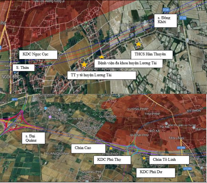
Affected residential areas.
The project starts at km0 at the eastern intersection of the road connecting to Gia Binh Airport in Trung Kenh commune and ends at km27+700 at the Duong River Bridge in Tri Qua ward, bordering Phu Dong commune in Hanoi.
The road is designed as a first-class plain road with a speed limit of 120 km/h and a parallel road with a speed limit of 60-80 km/h. The construction scale includes ten lanes with roads on both sides.
Six overpasses are planned along the route at intersections with provincial roads, national highways, or planned roads.
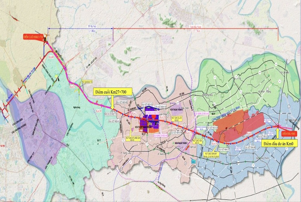
The 27.7-km road passes through eight communes and wards.
The project is undertaken by a joint venture between Cong Thanh Traffic Infrastructure Investment and Construction Joint Stock Company and Cam Pha Sun Company Limited (a member of Sun Group).
The total investment capital for the project is VND 47,607 billion, with the investor self-financing 100% of the capital. This includes 15% owner’s equity and 85% borrowed capital and other lawful capital mobilization.
As per the environmental impact assessment, the Gia Binh Airport and the connecting road are expected to boost regional economic development, especially in the fields of industry, logistics, and e-commerce, leveraging Bac Ninh’s strategic location in the key economic region of the North (Hanoi – Hai Phong – Quang Ninh – Bac Ninh).
The Green Light for the Metro Line 5: A 40km Route from Van Cao to Hoa Lac

The recently approved plan for the 5th metro line, an impressive 40km route with 20 stations and 2 large depots, is set to revolutionize travel in the city. This line, running from Van Cao to Hoa Lac, offers a significant portion of underground travel, starting from Van Cao and continuing through Lieu Giai, Nguyen Chi Thanh, and Tran Duy Hung. The above-ground and elevated sections begin after the National Convention Center, following the Thang Long Boulevard to its terminus at Hoa Lac.
The Future is Here: International-Standard, Multi-Functional Airport City to Rise Next to Hanoi

This project is a catalyst for a new era of development in the Northeast region, marking a pivotal turning point in infrastructure, urban landscapes, and international trade.
Signing a VND 56,000 Billion Contract for the Hanoi Ring Road 4 Highway Project Under the BOT Model

On September 3rd, the People’s Committee of Hanoi and the consortium of investors for the Ring Road 4 highway project (component project 3) – Capital Region, signed a Build-Operate-Transfer (BOT) contract worth over VND 56 trillion. This significant milestone paves the way for the investors and contractors to commence preparations for the project’s construction.
“NCB Visa Cards Shine Bright Across Hanoi for National Day Celebrations”

Introducing the NCB Visa card, a symbol of pride and patriotism, released just in time for the 80th anniversary of our nation’s independence. With its vibrant red and yellow colors, this special “Pride” edition card is a perfect tribute to our beloved country. Just like the vibrant hues of our national flag flying high across the streets, this card adds a special touch to your celebrations.
A Glimpse Beneath: Exploring the Crammed Vehicle Havens Under Hanoi’s Bridges

Despite being designed for traffic flow and with laws prohibiting parking, four large underpasses in Hanoi have been utilized as parking lots for years, due to the city’s desperate need for static parking spaces. This practice has led to several detrimental effects on urban traffic, causing a slew of issues for the city’s transportation system.


