


The creative and productive urban area, the new economic development of Bac Giang urban area
The Bac Giang Provincial People’s Committee has issued a Decision approving the tasks of Planning Zone 8, Bac Giang urban area, Bac Giang province, at a scale of 1/2,000.
Accordingly, the planned area belongs to the administrative boundary of Nham Bien town and the communes of Yen Lu, Canh Thuy, Tien Dung. The boundary is limited to the north by the foot of Nham Bien mountain and the Thuong river; the west and south by the Cau river and Que Vo town, Bac Ninh province; the east by the communes of Duc Giang and Tu Mai.
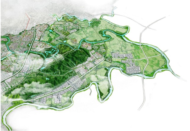
Planning Zone 8, Bac Giang urban area, Bac Giang province. Photo: CTTD Bac Giang.
The planning research area is about 4,378 hectares; the estimated population by 2030 is about 60,000 people, and by 2045 it is about 90,000 people.
In terms of characteristics, this is the southern gateway urban area, an important transportation hub connecting Bac Ninh, Hai Duong, and Quang Ninh provinces. It is a creative and productive urban area, a new economic development trend of Bac Giang urban area with an attractive and modern urban ecological space.
According to urban design, landscape design of key areas, key points, along main roads, open spaces, and landmark works. The key areas are identified as education and training centers, high-tech industrial production centers, port areas for trade with neighboring provinces via waterways, which are characteristic spaces and driving forces for development in the southern area of the city.
The main roads are defined as provincial road 398, the north-south axis 1,2 (according to the general plan) which is determined to be both a regional transportation route and a main urban axis, prioritizing the development of high-rise buildings, connecting the key functional areas and focal points, etc.
The open space system is planned as large park areas, landscape areas along the Thuong and Cau rivers, nursery areas, agricultural ecological areas connected with existing residential areas to create green lines, minimize environmental impacts. For newly regulated spaces in terms of density, building height, architectural form, they should be connected with suitable urban functional areas in accordance with the nature of the urban area, harmonize and unify with the existing areas.
The complex service center supporting the surrounding industrial zones
Meanwhile, the Bac Giang Provincial People’s Committee also issued a Decision approving the tasks of Planning Zone 6, Bac Giang urban area, Bac Giang province, at a scale of 1/2,000.
Specifically, the planned area belongs to the administrative boundary of Tan An town and the communes of Lao Ho, Xuan Phu, and part of Huong Gian commune. The boundary is limited to the north by Thai Dao commune, Lang Giang district; to the south by the Thuong river; to the east by Quynh Son commune, Lang Son commune and Luc Nam district; to the west by Huong Gian commune, the Thuong river.
The planning research area is about 2,048 hectares; the estimated population by 2030 is about 40,000 people, and by 2045 it is about 60,000 people.
Planning Zone 6, Bac Giang urban area, has the characteristics of a supporting urban area associated with the agricultural gateway, the Man stream flowing into the Luc Nam river, low hills in Lao Ho, Quynh Son area, and Tay Yen Tu tourist area. It is a complex service center supporting the surrounding industrial zones.
According to urban design, Planning Zone 6 is designed landscapes of key areas, key points, along main roads, open spaces, and landmark works. The key areas are identified as the Ngoi Man amusement park, the ecological tourism village of Lao Ho, the commercial and service center, the night economy center, the support center, and community health improvement center, which are characteristic spaces, driving forces and symbols of the eastern gateway area of the city.
The main roads are defined as provincial road 293, north-south axis (according to the general plan), which is determined to be both a regional transportation route and a main urban axis, prioritizing the development of high-rise buildings, large volumes, exploiting the advantages to form functional axes with value for the area.
The open space system is planned as green space areas (Ngùi Man amusement park, landscape areas along the Thuong river, agricultural ecological areas intertwined with existing villages), creating interconnected lines and green areas. For newly regulated spaces in terms of density, building height, architectural form, they should be connected with suitable urban functional areas in accordance with the nature of the urban area, harmonize and unify with the existing areas. Provide solutions for conservation and remodeling for existing construction areas.
The complex urban area, the new multi-functional center of Bac Giang
In addition, the Bac Giang Provincial People’s Committee also issued a Decision approving the tasks of Adjusting Planning Zone 2, Bac Giang urban area, Bac Giang province, at a scale of 1/2,000.
Accordingly, the planning area belongs to the administrative boundary of Le Loi, Dinh Ke, Tan Tien, Dinh Tri, Huong Gian, Xuan Phu wards and Tan An town. The boundary is limited to the northeast by Thai Dao commune (Lang Giang); to the south and southwest by the Thuong river dike; to the east by the planned road (belonging to Tan An town, Yen Dung district); to the northwest by the Hanoi – Lang Son expressway.
The planning research area is about 2,247 hectares; the estimated population by 2030 is about 66,000 people, and by 2045 it is about 105,000 people.
In terms of characteristics, this is a complex urban area, a new multi-functional center of Bac Giang city, with an urban ecological space attached to greenery and water surfaces and urban public service works.
Adjusting Planning Zone 2, Bac Giang urban area, at a scale of 1/2 000 is necessary to concretize and plan at a higher level, connect architecture, landscape, and infrastructure of component projects, promote the potential advantages of the expanded area, invest in constructing and completing the urban framework infrastructure system according to the plan, ensuring the targets of turning communes into wards.
The approved Planning Zone 2 will be an important legal basis for managing urban landscape architecture and carrying out further steps.


